
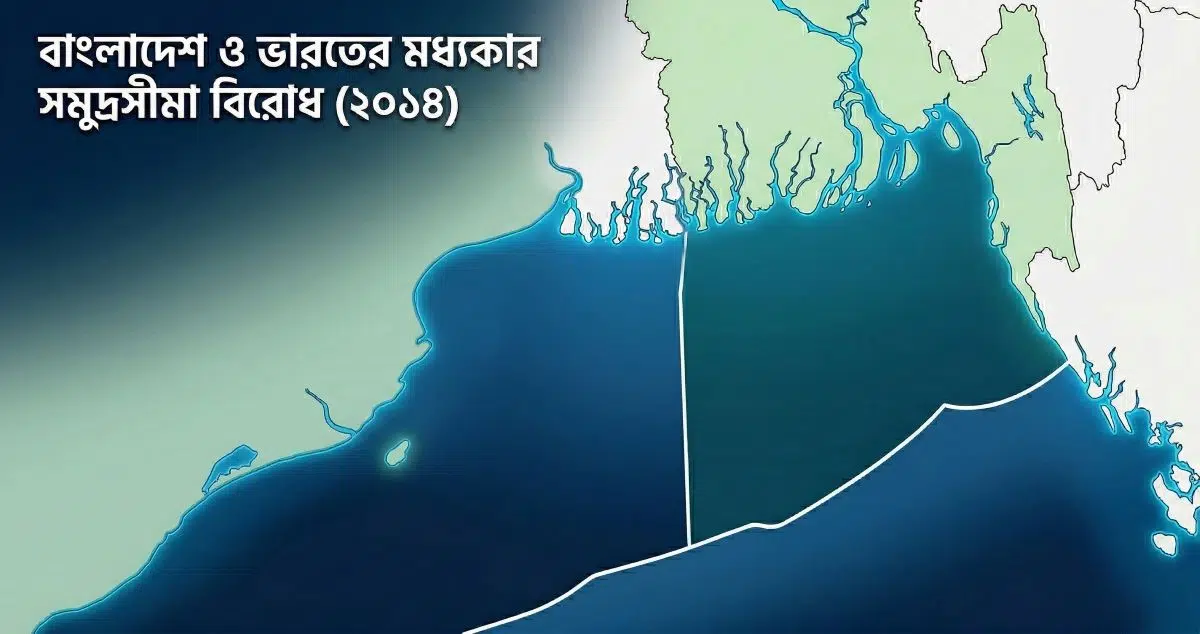
Just two years after securing a historic verdict against Myanmar at ITLOS, Bangladesh resolved its decades-long maritime impasse with its western neighbor. On July 7, 2014, the Permanent Court of Arbitration (PCA) in The Hague rendered its definitive award in the Bay of Bengal Maritime Boundary Arbitration between Bangladesh and India.
Constituted under Annex VII of the United Nations Convention on the Law of the Sea (UNCLOS, 1982), this adjudication was far more than an ordinary legal contest. It established an equitable maritime regime in South Asia, unlocking sovereign access to the continental shelf beyond 200 nautical miles and laying the cornerstone of Bangladesh’s national "Blue Economy."
Parliament may amend the Constitution, but it cannot dismantle its foundational architecture. An analytical inquiry into the judicial evolution of Bangladesh's Basic Structure Doctrine from Anwar Hossain Chowdhury to the Sixteenth Amendment.
Key Takeaways of the Verdict
- The Award: Rendered on July 7, 2014, by a five-member ad-hoc tribunal presided over by Ghanaian jurist Thomas A. Mensah.
- Territorial Allocation: Out of the disputed 25,602 square kilometers in the Bay of Bengal, Bangladesh was awarded 19,467 square kilometers (approximately 76% of the contested waters).
- South Talpatti (New Moore Island): Located on the western side of the Hariabhanga River's mid-channel flow, the territory was adjudicated to India (though the landmass had submerged by 2010).
- Jurisprudential Principle: The tribunal decisively rejected rigid geometrical equidistance in favor of equitable delimitation, accommodating the natural concavity of the Bengal delta coastline.
Context of the Dispute and Arbitration
Following liberation in 1971, bilateral negotiations between Dhaka and New Delhi repeatedly deadlocked over how to draw the maritime boundary from the mouth of the Hariabhanga River into the high seas. While bilateral talks remained paralyzed for nearly four decades, New Delhi deployed naval vessels in disputed gas blocks. On October 8, 2009, exercising its rights under Article 287 and Annex VII of UNCLOS, Bangladesh initiated compulsory binding arbitration proceedings against India.
Doctrinal Conflict: Equidistance versus Equity
India’s Argument: The Strict Equidistance Principle
India argued for a strict geometrical equidistance line drawn at an angle of 180° due south from the land boundary terminus. India contended that boundary delimitation must reflect the unadjusted coastal baseline. Had the tribunal accepted India’s submission, the acute concavity of Bangladesh's coast would have produced a catastrophic "cut-off" effect, hemming Bangladesh inside a narrow maritime wedge and blocking its access to the outer continental shelf.
Publish Your Research & Critical Analysis on MaroonPaper
Contribute in-depth essays on law, political philosophy, economics, and geopolitics to an intellectual readership.
Bangladesh’s Argument: The Equitable Solution
Bangladesh’s legal counsel demonstrated that the double concavity of the northern Bay of Bengal coastline created a macro-geographical anomaly. Invoking Articles 74 and 83 of UNCLOS, Bangladesh argued that the overarching objective of international maritime law is an equitable solution, not mechanical geometry. Strict equidistance would have severely penalized Bangladesh simply for possessing a recessed coastline.
Judicial Analysis and the South Talpatti Question
1. Delimitation Line and Continental Shelf Access
The PCA tribunal upheld Bangladesh’s contention regarding coastal concavity. Rejecting India’s 162° claim, the court adjusted the boundary line to an angle of 177° 30' from the coast. This adjustment averted the cut-off effect, allowing Bangladesh’s continental shelf to extend beyond 200 nautical miles to its natural limit in the Bay of Bengal.
A right without an enforceable remedy is an empty promise. Rooted in the maxim ubi jus ibi remedium, this jurisprudential study examines how Part III of the Bangladesh Constitution, Article 44, and the High Court Division's writ jurisdiction under Article 102 operationalize fundamental freedoms.
2. South Talpatti / New Moore Island
Under the 1947 Radcliffe Award, the border between East Pakistan and West Bengal was fixed along the main channel (thalweg) of the Hariabhanga River. Based on historical satellite bathymetry and hydrographic records, the tribunal determined that the island lay to the west of the main channel, falling within Indian sovereign waters. In practical terms, however, the low-lying sandbar—which emerged during the 1970 Bhola cyclone—eroded and sank completely beneath rising sea levels by 2010.
3. The "Grey Area" Phenomenon
Similar to the 2012 ITLOS Myanmar judgment, the PCA delimited a small "grey area"—a maritime sector where Bangladesh exercises sovereign rights over the seabed and subsoil (the extended continental shelf), while India holds sovereign rights over the superjacent water column (the 200 nm Exclusive Economic Zone).
Comparative Matrix: Claims versus Judgment
| Dimension | Indian Submission | Bangladeshi Submission | PCA Tribunal Award |
|---|---|---|---|
| Delimitation Line | 162° (Equidistance) | 180° (Angle-bisector / Equity) | 177° 30' (Adjusted Equitable Line) |
| South Talpatti | Indian Sovereignty | Bangladeshi Sovereignty | Adjudicated to India |
| Outer Shelf | Confined to 200 nm | Extended Continental Shelf (>200 nm) | Full sovereign rights to outer continental shelf recognized |
Conclusion
The 2014 PCA award stands as a triumph of international dispute resolution through international law. By peacefully submitting to compulsory arbitration, Bangladesh and India demonstrated that sovereign boundary disputes can be resolved without military confrontation. For Bangladesh, securing sovereign jurisdiction over 118,813 square kilometers of territorial sea, 200 nm EEZ, and up to 354 nm of outer continental shelf permanently fortified its national security and energy future in the Bay of Bengal.